Summary:
You’re planning a fence, adding a pool, or sitting at a closing table — and suddenly someone says you need a land survey. Maybe you already have one from when you bought the house. Maybe you have no idea what a survey even shows. Either way, you’re not alone. Land surveying is one of those services most homeowners don’t think about until something forces the issue. And when that moment comes, the questions pile up fast: What will it actually tell me? How long does it take? What’s it going to cost? This page answers all of that — plainly, without the industry jargon.
Different Types of Land Surveys and What Each One Actually Does
Not every survey is the same, and the type you need depends entirely on what you’re trying to accomplish. A homeowner in Massapequa adding a backyard deck has different needs than a developer in Garden City subdividing a commercial parcel. Knowing the difference upfront saves time, money, and a lot of confusion.
The most common request we get is for a boundary survey — a precise determination of your property lines based on deed records, historical documents, and field measurements. This is what most people picture when they hear “land survey.” It tells you exactly where your land begins and ends, and it’s typically required before any construction, permit application, or real estate transaction.
Land Survey Types: Boundary, Topographic, Title, and More

Beyond boundary surveys, there are several other types that serve specific purposes — and in Nassau County, each comes up regularly depending on where you live and what you’re doing with your property.
A topographic survey maps the physical features of a land parcel: elevation changes, contour lines, trees, structures, drainage patterns. If you’re building anything that requires grading or drainage planning — a new addition, a retaining wall, a significant landscaping project — a topographic survey is what your architect or engineer will need to work from. On the North Shore, where properties in communities like Oyster Bay and Roslyn often sit on hilly, wooded terrain with irregular lot shapes, topographic surveys are especially common.
A title survey (also called a mortgage survey) is what lenders and title companies require during a real estate transaction. It confirms the location of existing structures relative to property lines, identifies visible encroachments, and gives the title company what it needs to issue insurance. If you’re buying a home in Nassau County, your lender almost certainly requires one.
An elevation certificate is a different animal entirely. It’s a FEMA-required document that records the elevation of a structure relative to the base flood elevation for that area. In Nassau County’s South Shore communities — Long Beach, Oceanside, Freeport, Baldwin, Wantagh, Seaford, Massapequa — flood zone designations are a real and ongoing concern. After Superstorm Sandy in 2012, demand for elevation certificates across these communities surged dramatically, and many homeowners are still navigating flood insurance costs that a current, accurate certificate could help reduce.
ALTA/NSPS surveys are the highest standard in the industry — required for most commercial real estate transactions and by many institutional lenders. They combine boundary survey precision with a detailed review of easements, encroachments, and title matters, all meeting national standards set by the American Land Title Association.
Property Plat Survey: What It Is and When Nassau County Homeowners Need One
A plat survey — sometimes called a subdivision plat — is the official recorded map of a subdivided parcel of land. It shows individual lots, their dimensions, street layouts, easements, and other features relevant to the subdivision. If you’re subdividing property, selling off a portion of your land, or trying to understand how your lot relates to a larger recorded subdivision, a plat survey is the document that answers those questions.
In Nassau County, plat records are particularly important given the county’s history. Much of Nassau’s residential development happened in the post-World War II era — Levittown, East Meadow, Hicksville, Bethpage, and Wantagh were all built out rapidly in the late 1940s and 1950s. The original plats for these subdivisions are decades old, and the monuments that were placed at that time have sometimes been disturbed, buried, or removed over the years. Recovering those original boundary points requires research into historical records alongside careful fieldwork — not just a quick GPS reading.
This is where experience with local records genuinely matters. A surveyor who has been working in Nassau County for years has likely encountered the same subdivision plats, the same deed language, and the same monument conditions many times before. That institutional familiarity speeds up the process and reduces the chance of errors that could affect a permit application or a closing. It’s one of the reasons longevity in this business isn’t just a marketing point — it’s a practical advantage for the client.
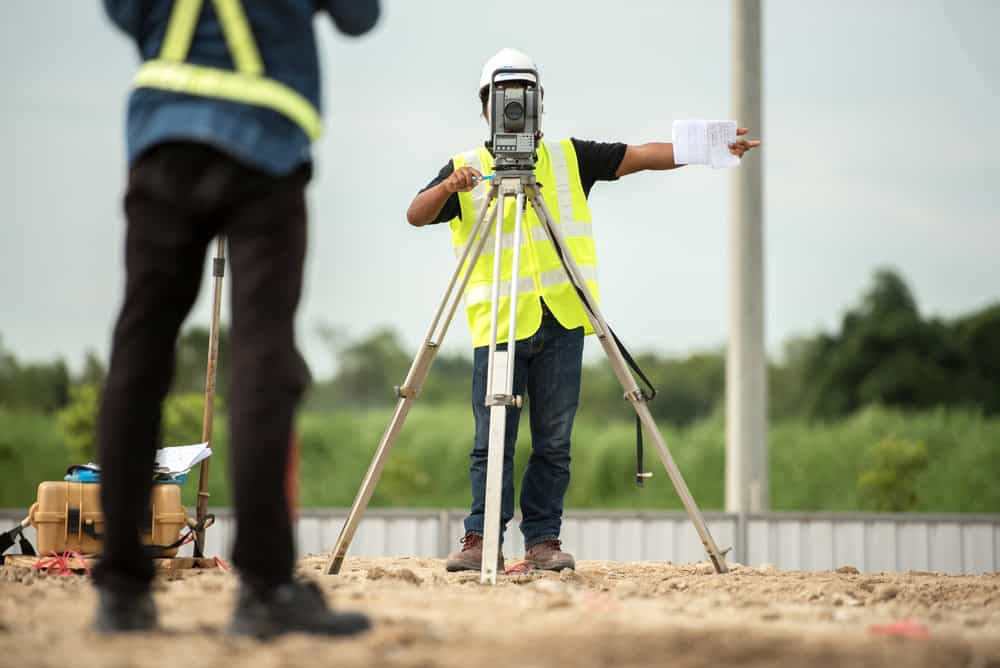
Surveying Engineering: The Technology Behind a Modern Land Survey
Most people assume that because GPS exists, land surveying is now fast, simple, and nearly automatic. The reality is more nuanced. Modern technology has made surveying significantly more accurate and efficient — but it hasn’t replaced the professional judgment, record research, and field expertise that a licensed surveyor brings to every project.
What has changed is the precision. Today’s equipment operates at a level that older methods simply couldn’t match, and that matters in a county as densely developed as Nassau, where a few inches of error can mean a fence on a neighbor’s property or a permit rejection from a local village building department.

Survey Technology: GNSS Surveying and What It Means for Accuracy
The backbone of modern land surveying is GNSS — Global Navigation Satellite System. It’s the broader category that includes GPS (the American system) as well as satellite networks operated by Russia, Europe, and other countries. Professional-grade GNSS receivers can achieve centimeter-level accuracy in the field, which is a significant leap beyond what traditional optical instruments could deliver.
RTK, or Real-Time Kinematic positioning, takes GNSS a step further. An RTK system uses a base station and a rover unit to calculate precise positions in real time, correcting for atmospheric interference and other variables that would otherwise introduce error. For boundary surveys, construction staking, and elevation work, RTK is now the industry standard for high-accuracy fieldwork.
That said, technology is only as useful as the person operating it and interpreting its output. A GNSS receiver placed at the wrong location — because the surveyor didn’t research the correct deed calls or couldn’t locate the original monuments — produces a precise measurement of the wrong thing. The research phase, which involves reviewing deeds, prior surveys, and municipal records before anyone sets foot on a property, is just as important as the field equipment. In Nassau County’s older subdivisions especially, that preliminary work often determines whether a survey comes back clean or uncovers complications that need to be resolved.
We use high-precision GNSS equipment and advanced surveying software on every project — not because it’s impressive to say, but because the alternative is a survey that might not hold up when it matters most.
Private Land Surveyor Qualifications in New York State
In New York State, only a licensed Registered Professional Land Surveyor — an RPLS — can legally sign and seal a survey document. That seal is what makes a survey legally valid and usable for permits, title insurance, real estate closings, and court proceedings. A survey without it is essentially just a drawing.
Earning that license isn’t a formality. It requires a combination of formal education (typically a bachelor’s degree in surveying or a related engineering field), a minimum of four years of supervised professional experience, and passing the national licensing exams administered by the NCEES — including both the Fundamentals of Surveying and the Principles and Practice of Surveying exams. Continuing education is required to maintain the license.
This matters to you as a client because it means there’s a licensed professional who is legally accountable for the accuracy of your survey. If something is wrong, there’s a professional standard and a regulatory body — the New York State Education Department — with oversight authority. That accountability doesn’t exist with an unlicensed provider, no matter how confident they sound on the phone.
When you’re comparing surveying firms in Nassau County, verifying that you’re working with a firm that employs licensed RPLS professionals should be the first step — before price, before timeline, before anything else. A cheap survey that gets rejected by your lender or challenged in a boundary dispute costs far more than the savings you thought you were getting.
Property Survey Prices in Nassau County: What Actually Drives the Cost
Survey pricing confuses a lot of people. You can call five firms and get quotes ranging from $400 to $3,000 for what sounds like the same job. The variation isn’t random — it reflects real differences in scope, property characteristics, and what the surveyor actually has to do to complete the work accurately.
Understanding the factors that drive cost helps you evaluate quotes more intelligently and avoid the trap of choosing the lowest number without knowing what it includes.