Land surveying isn’t just about measuring land anymore. Thanks to modern technology, it’s become a high-tech affair, especially on Long Island. Islandwide Land Surveyors are at the forefront, using cutting-edge tools to ensure precision and efficiency. Let’s take a closer look at how technology is reshaping property surveying in this neck of the woods.
What Tools Are Used for Land Surveying?
When it comes to land surveying, technology has transformed what used to be a painstaking manual process into a streamlined, efficient operation. On Long Island, Islandwide Land Surveyors are embracing these advancements with open arms. You might wonder, “What tools are used for land surveying today?” Well, say goodbye to theodolites and hello to drones and GPS systems. These tools are not just gadgets; they’re game-changers. They provide accurate data faster and with less manpower, which is a win-win for everyone involved.
GPS technology, for instance, allows surveyors to pinpoint locations with incredible accuracy. Meanwhile, drones give a bird’s eye view of the land, capturing high-resolution images that help in creating detailed maps. These tools, combined with traditional methods, make for a comprehensive approach to land surveying that’s both reliable and efficient. So, if you’re in Long Island and need some surveying done, rest assured that modern technology has got your back.
The Role of GPS in Land Surveying
GPS, or Global Positioning System, has become a cornerstone in modern land surveying. This nifty piece of technology enables surveyors to determine precise locations on Earth by using satellites. Gone are the days of endless tape measurements and rough estimates. On Long Island, GPS technology helps Islandwide Land Surveyors achieve pinpoint accuracy, which is crucial for property surveying and mapping.
With GPS, surveyors can work faster and more efficiently. It reduces the margin of error and increases the reliability of the data collected. Imagine trying to build a house without knowing the exact boundaries of your property—sounds like a nightmare, right? GPS ensures that such nightmares are a thing of the past, providing clear and accurate data that’s essential for any construction project.
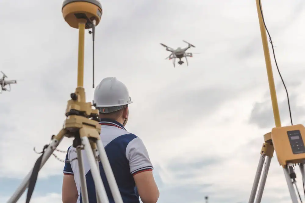
How Drones Enhance Property Surveying
Drones have taken to the skies and revolutionized property surveying. These flying wonders provide a unique perspective that traditional methods simply can’t match. On Long Island, Islandwide Land Surveyors utilize drones to capture detailed aerial images and videos of the terrain. This bird’s eye view helps in creating accurate topographical maps and 3D models of the land.
Drones are particularly useful in surveying large or difficult-to-access areas. They can quickly cover a lot of ground, capturing high-quality data without the need for extensive manpower. Plus, they’re just plain cool! By using drones, surveyors can provide clients with comprehensive reports that include visual data, making it easier to understand the lay of the land. It’s technology like this that makes property surveying on Long Island more efficient and precise than ever before.
The Importance of Technology in Land Surveying
Technology plays a pivotal role in modern land surveying, and nowhere is this more apparent than on Long Island. With urban development and environmental conservation often at odds, precise land measurements are crucial. Islandwide Land Surveyors leverage technology to ensure that these measurements are as accurate as possible. This is not just about drawing lines on a map; it’s about understanding the land and making informed decisions based on reliable data.
The integration of technology into land surveying also enhances safety and efficiency. Surveyors can collect data remotely, reducing the need for on-site visits in potentially hazardous areas. This not only speeds up the process but also minimizes risks to personnel. In a world where time is money, these advancements are invaluable, making the surveying process faster and more cost-effective.
Balancing Tradition with Innovation
While technology is crucial, it’s equally important to balance it with traditional surveying methods. On Long Island, Islandwide Land Surveyors know that sometimes the old ways are the best ways, or at least a great complement to new technology. Combining traditional tools with modern innovations ensures that every angle is covered and no stone is left unturned—literally.
Traditional surveying techniques, such as leveling and triangulation, still have their place, especially when dealing with complex terrains. These methods provide a solid foundation upon which modern technology can build. By marrying the old with the new, surveyors can offer a comprehensive service that meets the diverse needs of Long Island’s landscape. It’s this balance that sets Islandwide Land Surveyors apart, making them a trusted name in the industry.
Future Trends in Land Surveying Technology
The future of land surveying is as exciting as it is promising. On Long Island, Islandwide Land Surveyors are already looking ahead, exploring new technologies that could further enhance their services. One such trend is the use of LiDAR (Light Detection and Ranging), which uses laser pulses to measure distances and create highly accurate 3D representations of the terrain.
Another trend is the integration of artificial intelligence and machine learning. These technologies can analyze data more efficiently and predict potential issues before they arise. Imagine a world where your land survey not only tells you where your boundaries are but also suggests the best places to build or plant based on soil quality and sunlight exposure. It’s innovations like these that are set to redefine property surveying in the years to come.
Embracing Technology for Better Land Surveying
In conclusion, the role of modern technology in land surveying on Long Island cannot be overstated. Islandwide Land Surveyors are leading the charge, using tools like GPS and drones to provide accurate, efficient, and safe surveying services. By embracing both traditional and innovative methods, they ensure that every survey is comprehensive and reliable. As technology continues to evolve, so too will the methods used in land surveying, promising even greater precision and efficiency in the future. So, if you’re in need of land surveying services, look no further than the tech-savvy experts at Islandwide Land Surveyors.